
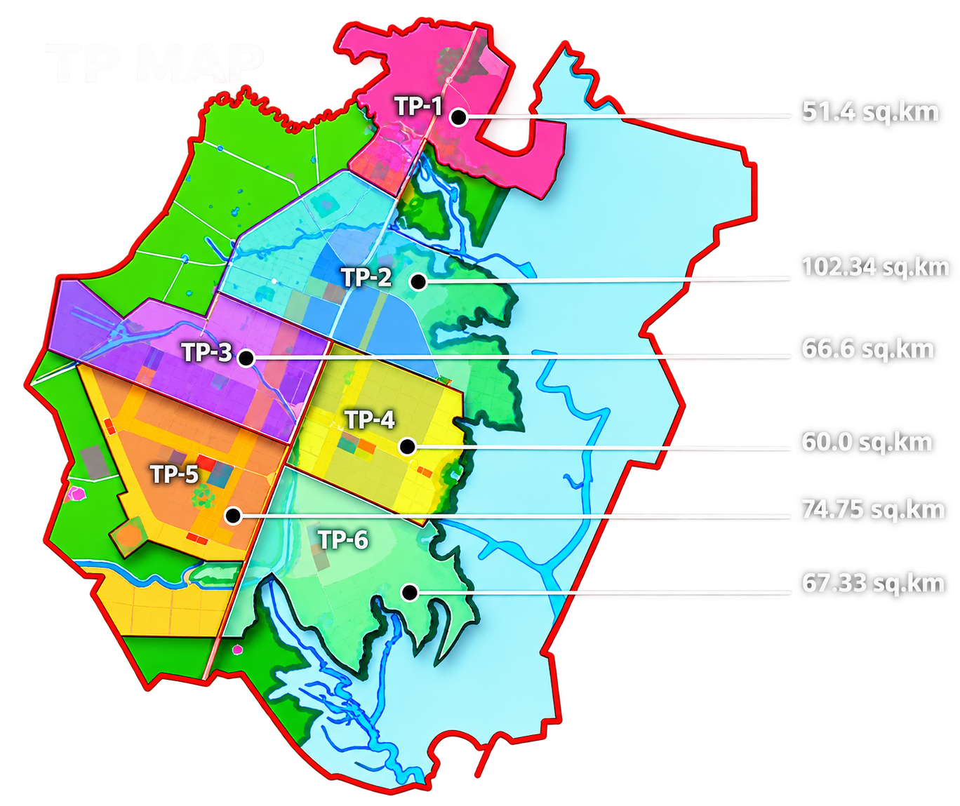
10.1 What is a TP scheme?
"TP" stands for Town Planning. In Gujarat, a town-planning scheme (also called a TPS) is a statutory instrument prepared under the Gujarat Town Planning and Urban Development Act, 1976 — the same law, GTPUDA, that anchors Dholera's whole planning framework. A TP scheme takes a defined patch of land, redraws it, and reallocates it: some land becomes roads, some becomes parks and civic sites, and the remaining land goes back to the original owners as reshaped, serviced plots.
The idea is older than Dholera by decades. Gujarat has used TP schemes since the mid-twentieth century to build out cities like Ahmedabad. What makes Dholera notable is scale: a region being assembled through a series of large schemes rather than a handful of small ones.
Two definitions matter before going further. The Original Plot (OP) is the piece of land an owner holds when the scheme begins: the field as it exists on the revenue record today. The Final Plot (FP) is the reshaped, legally reconstituted plot the same owner receives back after the scheme redraws the area. Almost everything in this chapter hangs off the movement between those two.
10.2 Why TP schemes are used
Why not simply buy the land and build? Because compulsory acquisition is slow, expensive and politically bruising, and because a plan drawn on a blank sheet has to meet real property lines eventually. A TP scheme avoids both problems at once. No one loses their land entirely; owners keep a share, returned as developed plots in the same general area. And the plan actually gets implemented: the redrawing process physically aligns everyone's boundaries with the road grid and utility network.
The trade is simple in principle: every owner contributes some land, free of compensation, to roads, utilities and public purposes. In return, whatever comes back is worth more per square metre: it has road frontage, legal building potential and services nearby. The scheme then taxes part of that value gain (betterment) to pay for the works. This is land value capture done through geometry.
The community story (who participates, what it means for farmers, where disputes have arisen) is covered in Chapter 9, land pooling. This chapter stays with the mechanism.
10.3 TP stages
A TP scheme does not appear finished. Gujarat's law moves a scheme through a fixed sequence of drafts, notices, objections and sanctions. Each stage changes what the scheme can lawfully do. The sequence matters in practice, because a claim that "a TP has been sanctioned" can mean very different things depending on which stage it actually reached.
| Stage | What happens | What it means legally |
|---|---|---|
| Draft TP scheme | TS&CP/DICDL prepares the proposal: boundaries, roads, proposed land uses and the rough reconstitution arithmetic. It is published and notified. | A proposal. It can be modified or dropped. No one is entitled to anything yet. |
| Preliminary scheme | Objections from landowners are heard, the plan is revised, and the state government grants preliminary (first) sanction. | The broad structure (roads, reservations, plot pattern) is provisionally fixed. Work can begin on parts of it. |
| Final scheme | The detailed plot-by-plot reconstitution is settled, final sanction is granted, and final plots are formally allotted. | Owners acquire a legally constituted right to a Final Plot with a number on the scheme. |
| Implemented | Physical works (roads, water, drainage, power) are executed on the ground, and the record is updated. | A sanctioned scheme is not a serviced plot. Services exist only when they are built and commissioned. |
Most confusion in the public conversation about Dholera comes from skipping that last row: a scheme at draft stage, a scheme with final sanction and a scheme with live infrastructure are three different realities that share one name. It is the first thing I point people to when they ask, flatly, whether "the TP land in Dholera is developed."
10.4 Draft, preliminary and final: the same thing twice
It helps to see stage 10.3 as two passes over the same area. The first pass (draft to preliminary) settles the skeleton: where the major roads run, where reservations sit, roughly how much land each category takes. The second pass (final) settles the individual arithmetic: exactly which owner gets which Final Plot, of what dimensions, with what deductions recorded against their name.
Between the passes there is a formal objection window. Landowners can challenge boundaries, the extent of deductions or the siting of reservations. That is why preliminary and final sanction dates can be years apart, and why published scheme maps often carry revision dates.
TP1 and TP2, the region's first two schemes, had draft schemes sanctioned on 24 October 2013, together covering roughly 153 sq km as the first development phase. Later schemes have progressed through the same machinery at different paces. Individual stage dates for each scheme require checking against the relevant official notifications, which this site maintains separately in its verification records.
10.5 Original Plot (OP)
The Original Plot is the owner's land as it stands when the scheme is drawn: the survey number as it appears in the revenue record. An OP might be a neat rectangle; more often it is an irregular field bounded by rain-fed tracks, village paths or a neighbour's line. It typically has no formed road frontage, no piped water and no legal non-agricultural status.
Three things define an OP in the scheme's account book:
- Area: the exact measured extent, which becomes the base for calculating what comes back.
- Position: where it sits relative to planned roads and reservations. An OP on a future arterial road and one in the interior contribute very differently.
- Title: who owns it. Every co-sharer and successor on the record must be traced before a Final Plot can be allotted.
One-line summary for later reference: the OP is the input. It is what the scheme measures, not what the scheme produces.
10.6 Final Plot (FP)
The Final Plot is the output. It is the plot the scheme allots back to the owner after reconstitution, reshaped to fit the new road grid, sized according to the reconstitution arithmetic, and located in the same general vicinity as the OP (Gujarat's law generally keeps the returned land near the original holding, though not always on the identical spot).
A Final Plot differs from an OP in ways that go beyond shape. It has a scheme-level identity: a Final Plot number that planners and authorities use instead of the old survey numbers. It normally has planned road access. It is positioned within the scheme's zoning, which decides what the DGDCR development regulations will and will not allow there. And it is the plot against which betterment charges, if levied, are assessed.
Picture two neighbouring one-hectare fields, A and B. Field A happens to sit on the line of a planned 60-metre road; a large slice of it must be surrendered to the road corridor. Field B sits in the interior. When the scheme finishes, owner A receives a smaller Final Plot, the road having consumed a big share, but it sits on a major artery. Owner B gives up proportionally less and receives a larger Final Plot, but one on an internal street. Same starting size, different outcomes. That asymmetry is not a judgement about either owner; it is just the arithmetic doing its work.
10.7 Reconstitution
Reconstitution is the formal name for the redistribution: the process by which the scheme pool is built and then paid back out. It runs in three moves.
First, the pool is assembled. Each OP contributes a share of its area to public purposes (road corridors, civic sites, utility reserves), without compensation, purely by arithmetic on paper.
Second, the arithmetic is applied. Gujarat's scheme practice commonly returns owners on the order of half or more of their original holding as Final Plot area, with the balance diverted to roads, reservations and (in some schemes) commercially utilised land whose sale funds infrastructure. The exact percentages vary scheme by scheme and stage by stage, and Dholera-specific deduction ratios are a matter this site treats as requiring a dated official record before being stated, so none is asserted here.
Third, the pool is paid back out. Owners receive Final Plots in the same vicinity as their OPs, and the state records the transaction in the scheme's reconstitution statement: a schedule listing every OP, its deductions and its corresponding FP.
Reconstitution is also why land records in Dholera can look confusing. An old parcel may carry three identities: the original survey number, the draft-scheme plot number and the final-scheme Final Plot number. Due diligence means reconciling all three; the newest number on its own will mislead you.
10.8 Roads and reservations
The most visible output of any TP scheme is its road network. The scheme fixes road hierarchy inside its boundary (arterials, sub-arterials, collector and local streets) and carves their corridors out of the land pool before any Final Plot is allotted. In Dholera, that grid then connects to the wider movement network planned at the master-plan scale; the relationship is described in Chapter 8, the master plan.
Reservations are the second carve-out. The scheme designates specific sites for public purposes: parks and open spaces, schools and civic buildings, utility plots for water, sewage treatment and electrical infrastructure. These sites do not return to any owner as Final Plots; they vest in the planning authority.
Two practical notes for reading any scheme. First, road corridors are wide but not infinite: a 60-metre road consumes a serious share of adjacent land, which is why position relative to planned roads drives reconstitution outcomes. Second, a reservation shown on a map is a plan, not a facility. A "school site" that is a fenced field has not yet been built.
10.9 Public-purpose land
Public-purpose land is the umbrella term for everything the scheme holds back: the road corridors and reservations above, plus land acquired for infrastructure of wider benefit. It is the portion of the pool that funds the deal itself: the reason owners accept deductions is that this land buys the services that make the returned plots valuable.
In practice, public-purpose land in a TP scheme typically falls into four buckets: movement (roads, and sometimes transit reserves), green and social (parks, playgrounds, civic sites), utility (water, drainage, power, waste), and, in some Gujarat schemes, saleable commercial land used to cross-subsidise the works. Which buckets a specific Dholera scheme uses, and in what proportions, belongs to that scheme's own sanction documents rather than to any general rule.
10.10 Sub-TP concepts
A scheme covering 50–100 sq km is too large to design, sanction and service in one motion. The remedy is the Sub-TP: a sub-division of a parent TP scheme that is planned and progressed as its own unit, with its own roads, reservations and reconstitution arithmetic, inside the parent's boundary.
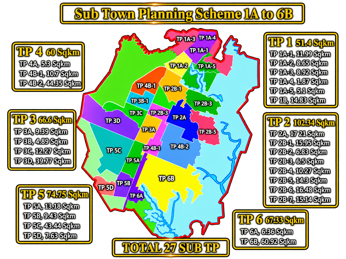
Sub-TPs exist because the parent scheme fixes the big moves (how the area connects, where the broad land-use bands run) while the Sub-TP settles the local questions at a workable scale: street layout, neighbourhood reservations, plot sizes. They also create naming conventions that dominate Dholera's planning vocabulary: TP2A, TP4B and similar labels identify specific sub-schemes inside the parent.
The Dholera region is officially described as using 6 TP schemes within a sanctioned TP footprint of 422 sq km, subdivided into Sub-TPs (per the state government's planning page); the exact count of Sub-TPs (often cited as 27) should still be confirmed against a current official scheme matrix before being relied on. The principle, however, is settled: the TP is the legal frame, the Sub-TP is the working unit.
10.11 Linear TP
Alongside the conventional schemes, Dholera's planning uses a distinct mechanism usually described as a linear town-planning approach: development organised along and outward from a major corridor, rather than delivered as a sequence of area schemes alone. The concept treats the central high-access corridor as a spine, and extends planning and servicing progressively outward from it in bands.
Linear TP is referenced in official and semi-official material about the region's next phases, but the site's current verification record treats its specifics (boundaries, stages, status) as requiring dated official documentation before being stated as fact. What can be said safely is that it is a recognised planning mechanism in the Dholera toolkit, designed to let infrastructure follow a corridor and let development density step down with distance from it, and that its use in Dholera is a current-planning question rather than settled history.
10.12 How TP connects to infrastructure
A TP scheme is where the infrastructure plan gets its address. The master plan says "trunk water will serve this area"; the TP scheme says which corridor carries it, which site hosts the pumping or treatment works, and which Final Plots it passes. Roads, drainage, power and water all receive their reserved space inside the scheme before any plot is allotted.
That is why serviced-land claims in Dholera ultimately trace back to TP mechanics. A Final Plot in a scheme whose road corridors and utility reserves are physically built is a different asset from an identical-looking plot in a scheme that exists only on paper. The plot's position in the TP, and the TP's stage, is a proxy for when services can realistically reach it. The regional infrastructure programmes themselves are covered in the Infrastructure section; here the point is structural: no services without reserved corridors, no corridors without the scheme.
10.13 How to read a TP map
TP maps are intimidating at first sight, but they follow conventions that anyone can learn. A generic reading sequence:
- Start with the legend. It defines the colour and hatch codes. Gujarat scheme maps conventionally show roads in one style, reservations (parks, civic sites, utilities) in coded colours, and Final Plots as numbered parcels. Colours vary between documents, so the legend, not memory, is the source of truth.
- Find the north arrow and scale. Orientation and scale let you match map features to the ground and to other maps of the same area, which are often drawn at different scales.
- Read the plot numbering. Final Plots carry scheme numbers (often prefixed FP), usually with the area written alongside. Original survey numbers may appear in a different style. Learning to tell the two apart is the single most useful map-reading skill here, because it is how you check whether a document is describing land before or after reconstitution.
- Trace the road hierarchy. Widest corridors are arterials; narrower lines are local streets. Where a wide corridor crosses a scheme boundary, it will reappear in the neighbouring scheme; boundaries are administrative, roads are continuous.
- Note the reservations. Reserved sites are the land that does not return to owners. Their positions tell you where future social and utility facilities are planned.
- Check the date and revision. Scheme maps get revised between draft, preliminary and final stages. An undated or old map may not represent the scheme in force.
A caution: these are reading conventions, not claims about any specific map document. Which map versions exist, and where official copies can be obtained, is a sources question this site tracks in its verification records rather than asserting here.
10.14 TP status vs ground reality
The last skill is separating what a TP scheme means legally from what exists physically. They move on different clocks.
A TP scheme, at final sanction, is a legally constituted plan: roads and reservations are fixed, Final Plots exist on the record, and owners hold defined rights. None of that requires a single road to be built. Ground reality, meaning formed roads, live water and power, occupied plots, arrives only through the implementation stage, and can lag the sanction by years.
Conversely, physical progress in one Sub-TP says little about another. Because Dholera is being assembled through multiple schemes at different stages, any single status statement ("TP land is developed", "TP land is pending") is too coarse to be accurate. What is true of the Activation Area's schemes is not true of the region's other schemes.
So the correct unit of truth is small: one scheme, one stage, one date. This chapter has explained what those words mean. Where Dholera's schemes currently stand (which works are built, which services are live, which areas remain on paper) is deliberately kept out of this permanent explainer and maintained in Chapter 6, Dholera ground reality, which is refreshed against dated evidence.