
5.1 The short answer
Dholera is on the coast of the Gulf of Khambhat, in Ahmedabad district of Gujarat, south-west of the city of Ahmedabad. It sits in the low-lying coastal plain known locally as the Bhal region: flat, open land where the Gulf's shallow waters meet farmland and village settlements. Across the Gulf to the south-east lies Bhavnagar, a major Saurashtra city; to the north, the road and (soon, potentially) rail connections run back toward Ahmedabad, the state's largest city. To the east along the same coast sits Lothal, one of the most important Harappan archaeological sites in India, close enough that tour itineraries pair it with Dholera, yet an entirely separate site with its own history.
Plot it on a map and three reference points do the framing. Ahmedabad is the economic gravity to the north-east, the source of commuters, cargo and capital the project is designed to capture. Bhavnagar is the regional counterpart across the Gulf to the south, administratively a neighbour and geographically a sea-arm apart. And the Gulf of Khambhat itself is the third frame: a shallow, tide-dominated embayment whose mudflats and salt-affected lands gave the Bhal its character long before anyone proposed a city here.
For a single fixed project reference point: the modern project area is centred on the Dholera Special Investment Region (DSIR), a planning envelope of roughly 920 sq km of Ahmedabad district, formalised under the Delhi–Mumbai Industrial Corridor programme. Within it sits a much smaller patch, the Activation Area, where the first phase of city-building has actually been concentrated.
One well-supported travel fact anchors the distance question: the Ahmedabad–Dholera Greenfield Expressway is 109.019 km long, and it was inaugurated and dedicated to the nation on 31 March 2026 per the Prime Minister's Office event record. That is a verified length. On travel time we repeat no headlines: what we can say from our own runs on the road is that the drive lands around the 55-minute mark from Ahmedabad (📍 ground-verified, September 2026). Expect that number to move with traffic, weather and which stretch of the city you start from.
5.2 The four things called "Dholera"
This is the single most useful distinction a reader can make, because news articles, real-estate brochures and even official documents use these names loosely and interchangeably. Learn to tell the four apart and a good share of the nonsense written about this place collapses on contact. At least four distinct things answer to the name "Dholera":
- Dholera village / town. The actual settlement: a small town with a centuries-long history as a coastal trading centre, today an administrative and market centre for the surrounding villages. It predates every modern project here by many centuries.
- Dholera SIR (DSIR). The Dholera Special Investment Region: a legal and planning framework covering roughly 920 sq km of Ahmedabad district under the Delhi–Mumbai Industrial Corridor. Official records describe it as the largest node under DMIC, managed through Dholera Industrial City Development Ltd (DICDL), a central–Gujarat government special purpose vehicle. It is a jurisdiction, not a built place.
- The Activation Area. The first-phase development zone inside DSIR, officially described at approximately 22.54 sq km in the government's February 2026 status note and NICDC's project description. This is where trunk infrastructure has been built and where "Dholera city" most concretely means something today.
- The new city / port ambition. The long-term vision of a greenfield industrial city and maritime gateway. This is the thing headlines usually mean by "Dholera". Most of it remains planning and construction-stage material, described in detail in the timeline and infrastructure chapters.
Related names add their own confusion. Dholera Taluka is an administrative sub-district, and it does not match the DSIR boundary. The Dholera International Airport site sits inside the wider project area but is its own project with its own status. And Lothal, the famous Harappan archaeological site, is a short distance away in the same coastal region but is not part of the Dholera SIR. It shares the neighbourhood, nothing more.
| Name | What it refers to | Approx. area | Status |
|---|---|---|---|
| Dholera village / town | The historic settlement and its inhabitants | A few sq km (settlement scale) | Exists, centuries old |
| Dholera SIR (DSIR) | Legal planning jurisdiction under DMIC, managed by DICDL | ~920 sq km | Notified planning framework; development is phased |
| Activation Area | First-phase development zone inside DSIR | ~22.54 sq km (Feb 2026 official note; definitive figure pending latest map record) | Trunk infrastructure established; "almost complete" per Feb 2026 status |
| New city / port ambition | The long-term greenfield city and maritime gateway vision | Conceptual — no fixed boundary | Vision and phased construction, not an operating city |
| Dholera Taluka | Administrative sub-district | Does not match DSIR boundary | Administrative unit |
| Dholera Airport site | Dholera International Airport project | Separate project footprint within the wider area | Under construction (see /infrastructure/connectivity/) |
| Lothal | Harappan archaeological site, same coastal region | Heritage site | Not part of DSIR |
A note on the Activation Area figure: dated official records (PIB, February 2026; NICDC; DPIIT's FY 2024–25 report) consistently use approximately 22.5–22.54 sq km, so that is the best current published figure. A narrower working figure (~21.5 sq km) also circulates in project discussions; the definitive current boundary awaits the latest authoritative project or map record, so treat 22.54 sq km as "the latest dated official figure", not a final answer.
5.3 Why the name confusion matters
This is not pedantry. The names get mixed up everywhere, and the mix-up has consequences:
- News articles routinely say "Dholera" when they mean DSIR, the Activation Area, or just the expressway endpoint. A headline like "Dholera gets ₹X crore" usually refers to a specific scheme or zone inside the 920 sq km, not a cheque for the whole region.
- Real-estate marketing borrows the prestige of the whole project ("Dholera") for parcels that may be far outside the SIR boundary, in surrounding villages or talukas. The name itself guarantees nothing about location, approval or servicing.
- Officials and even government documents slide between "Dholera", "DSIR" and "Dholera Industrial City" without always defining which one they mean.
- Practical consequences: if you are booking a site visit, the question "which Dholera?" decides everything: the historic town, the Activation Area where trunk infrastructure stands, or some other corner of the 920 sq km envelope. Different destinations, different distances, different realities.
It is also worth naming how the confusion gets produced, because it is rarely a simple mistake. Project communications compress a complex, multi-zone, multi-decade programme into one brandable word, because "Dholera" is simpler than "the Activation Area within the Dholera Special Investment Region within the Delhi–Mumbai Industrial Corridor". Media inherits that compression and amplifies it. Then brochures, listicles and forwarded messages inherit it in turn. By the time a claim reaches a prospective visitor or buyer, the zone, project or phase it originally referred to has usually been lost entirely. The only reliable fix is the habit this chapter teaches: always re-expand the word "Dholera" back into a specific entity, and check it against a specific boundary or project record.
5.4 The geography itself
Dholera sits in the Bhal region, a low, flat coastal plain where the Gulf of Khambhat (the arm of the Arabian Sea between the Saurashtra peninsula and mainland Gujarat) meets the land. The Gulf is famously shallow, with an enormous tidal range. At low tide vast mudflats are exposed and the shoreline shifts gradually across the plain; the flats themselves smell of salt and wet mud. This is a genuinely coastal setting. The sea's influence on soil, water and daily life is not theoretical. For centuries the tide carried salt inland and back with every cycle, and the flat land gave the water nowhere to go quickly.
The climate is semi-arid: hot summers, a concentrated monsoon, modest total rainfall. The year runs on two extremes. There is a long dry season when the land bakes and salt concentrates near the surface, and a short monsoon when the flat terrain ponds with water faster than it can drain. Flat land, tidal water and seasonal rain have left the region a long history of soil salinity; seawater ingress and poorly draining ground shaped what farmers could grow for generations. Traditional cultivation in the Bhal adapted accordingly, and its agricultural reputation was built on crops that tolerated exactly these conditions. (The fuller story of how this landscape was transformed and eventually chosen for the city project is told in Chapter 2 — The Revival Story.)
The flatness itself deserves a sentence. There is almost no natural gradient across much of the project area, so gravity drainage is limited and the land's instinct, under rain and tide, is to hold water. That is not a fatal flaw and not a triviality either; it is simply the engineering premise of the whole project. Before a coastal plain like this can carry city-scale loads, water has to be moved on purpose, with engineered drainage, flood protection and storage, rather than left to find its own slow way out.
Which flood and drainage systems have actually been built, and which are only planned, is a verification-sensitive question we track separately in Infrastructure; the environmental and flood-risk picture is treated honestly in Chapter 6. What we will not do here is assert completed flood works without dated project records.
5.5 Getting there
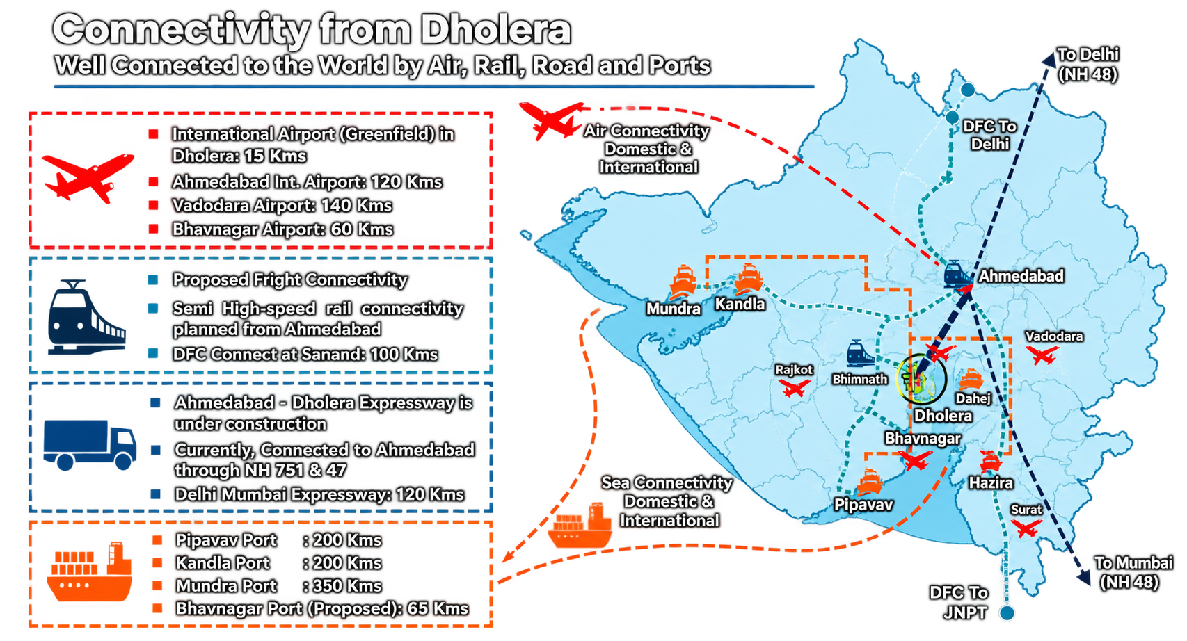
Connectivity is the practical reason location matters. Here is the orientation-level picture, with statuses stated carefully:
- Road: the expressway. The 109.019-km Ahmedabad–Dholera Greenfield Expressway was inaugurated and dedicated to the nation on 31 March 2026 (PMO primary record). It is the flagship physical connection between Ahmedabad and the Dholera area. Traffic volumes and full corridor operating detail still need separate primary documentation; on travel time, our own runs put the Ahmedabad–Dholera leg around the 55-minute mark (📍 ground-verified, September 2026). For status language, see /infrastructure/connectivity/.
- Rail: approved, not running. An Ahmedabad (Sarkhej)–Dholera semi-high-speed double-line rail project was approved in May 2026 (Ministry of Railways record): approximately 134 km, estimated ₹20,667 crore, with a completion horizon extending to 2030–31. It is a plan, not a service. The next milestone has landed, though: Western Railway floated the EPC tender for the line in August 2026, valued at ₹18,901.68 crore, so procurement is formally under way. Construction has not begun; construction completion and passenger operations should not be described as current facts. The full rail picture, including what is not verified, is in Chapter 12 / the rail corridor material.
- Airport: under construction. Dholera International Airport was reported at approximately 80% overall construction at a 14 July 2026 official review, with runway, taxiway and ATC structures complete and the passenger terminal 75% complete. That is a construction snapshot, not an operating airport. Licensing and commercial operations remain separate, unverified milestones. Details: /infrastructure/connectivity/.
- Existing roads. Before the expressway, everyday access ran via the conventional road network linking the Dholera area back toward Ahmedabad along the Ahmedabad–Bhavnagar corridor. The expressway does not erase these roads; for everyday travel to the town and villages, ordinary state highways still carry most local movement. (Precise highway designations and route details require verification before we publish them.)
Two orientation habits help anyone planning travel. First, decide the destination before the route: "going to Dholera" could mean the town, the Activation Area gate, the airport site or a village in the surrounding taluka, and the expressway does not serve all of them equally. Second, treat every travel-time estimate as a claim, not a fact. Drive times depend on the endpoint, the time of day and how much of the connecting network is actually in use, and no single headline number settles any of that.
5.6 A simple orientation exercise
Imagine standing in the Activation Area today. (Go in person if you ever can; the exercise lands differently at ground level.) You are on flat, open coastal plain in Ahmedabad district, roughly south-west of Ahmedabad, inland a modest distance from the Gulf of Khambhat's shoreline. Around you: wide straight roads and drained plots laid out on a grid that did not exist a decade ago, trunk utilities running in organised corridors, and the older village and farmland country continuing past the zone's edges. The scale is deceptive. The Activation Area is only about 22.54 sq km of a 920 sq km planning region, so what feels like "Dholera" from inside the zone is, on a district map, a small patch.
Two honest caveats. First, "almost complete" in the government's February 2026 language refers to trunk infrastructure (roads, drainage, utilities), not a finished, functioning city; the population, occupancy and operating-business picture is a separate and smaller story (see Chapter 6). Second, what you would see at the town of Dholera itself, versus the Activation Area, versus the wider DSIR, are three different views of the same name, which is exactly the confusion this chapter set out to fix.
Run the same mental exercise for the other three entities and the picture sharpens further. This is the part of the chapter I would keep if I could keep only one piece of it. Stand in the town of Dholera and you see a living settlement: houses, markets, a temple, roads worn by daily use. It has carried the name for centuries and will carry it long after the project's fate is decided. Stand on the DSIR boundary anywhere other than the Activation Area and you will most likely still see farmland and village land, because the 920 sq km framework is mostly a legal envelope, not a construction site. Stand at the airport site and you see a large construction project in progress. Four names, four very different views. Every honest conversation about Dholera starts by saying which one you mean.
5.7 What to read next
- Chapter 6 — Dholera Ground Reality: what physically exists on the ground today.
- Chapter 4 — The Timeline: how the project unfolded, year by year.
- Connectivity guide: roads, rail, airport and logistics with honest status language.
- Dholera 101 hub: the full course, chapter by chapter.