
This chapter explains what each connection is and why it was built the way it was. It does not track construction percentages or opening dates. Current physical status is maintained in Chapter 6 — Dholera ground reality, and dated events in Chapter 4 — the timeline. Energy systems are covered separately in Chapter 14 — energy (that section is still being built, but the route is live).
Practical numbers first: Ahmedabad to Dholera distance, routes and travel time · and what is actually planned on metro and MRTS.
One idea before the detail
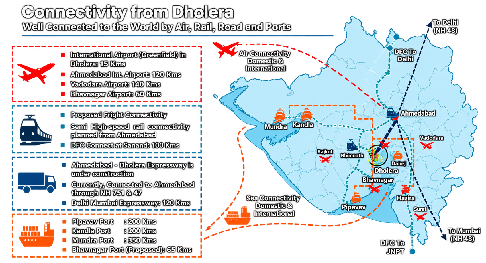
Dholera is the largest node of the Delhi–Mumbai Industrial Corridor, planned at 920 sq km. A city planned at that scale cannot run on state highways alone. The connectivity plan pairs each gap with a mode: a greenfield expressway for the road gap, a semi-high-speed rail line for mass movement of people, a greenfield airport for air cargo and passengers, and a proxy-port strategy that routes maritime trade through existing Gujarat ports instead of building an impossible one locally. The DMIC strategic context is covered in Chapter 3 — Dholera's DMIC position.
| System | What it is | Where its status lives |
|---|---|---|
| Ahmedabad–Dholera Expressway | 109.019 km access-controlled greenfield expressway, designated NH-751 / NE-8 | Ch. 6 |
| Road network | Internal SIR grid, TP roads and link roads feeding the expressway | Ch. 6 |
| Dholera International Airport | Greenfield Code 4E airport at Navagam, AAI-majority owned | Ch. 6 |
| Rail connectivity (existing) | Conventional broad-gauge lines serving the wider region today | Ch. 6 |
| Ahmedabad–Dholera rail corridor | Approved ~134 km semi-high-speed double line, Sarkhej to Dholera | Ch. 6 |
| Freight and logistics | Dedicated Freight Corridor access via the wider corridor network | Ch. 6 |
| Port connectivity | No port at Dholera; road and rail links to existing Gujarat ports | Ch. 6 |
| Maritime logistics | Proxy-port strategy through Pipavav, Kandla, Mundra and a modernised Bhavnagar | Ch. 6 |
| Multimodal logistics | Warehousing, freight villages and interchange points where modes meet | Ch. 6 |
| Regional and national links | How the local systems plug into NH corridors, DMIC and national networks | Ch. 6 |
12.1 The Ahmedabad–Dholera Expressway
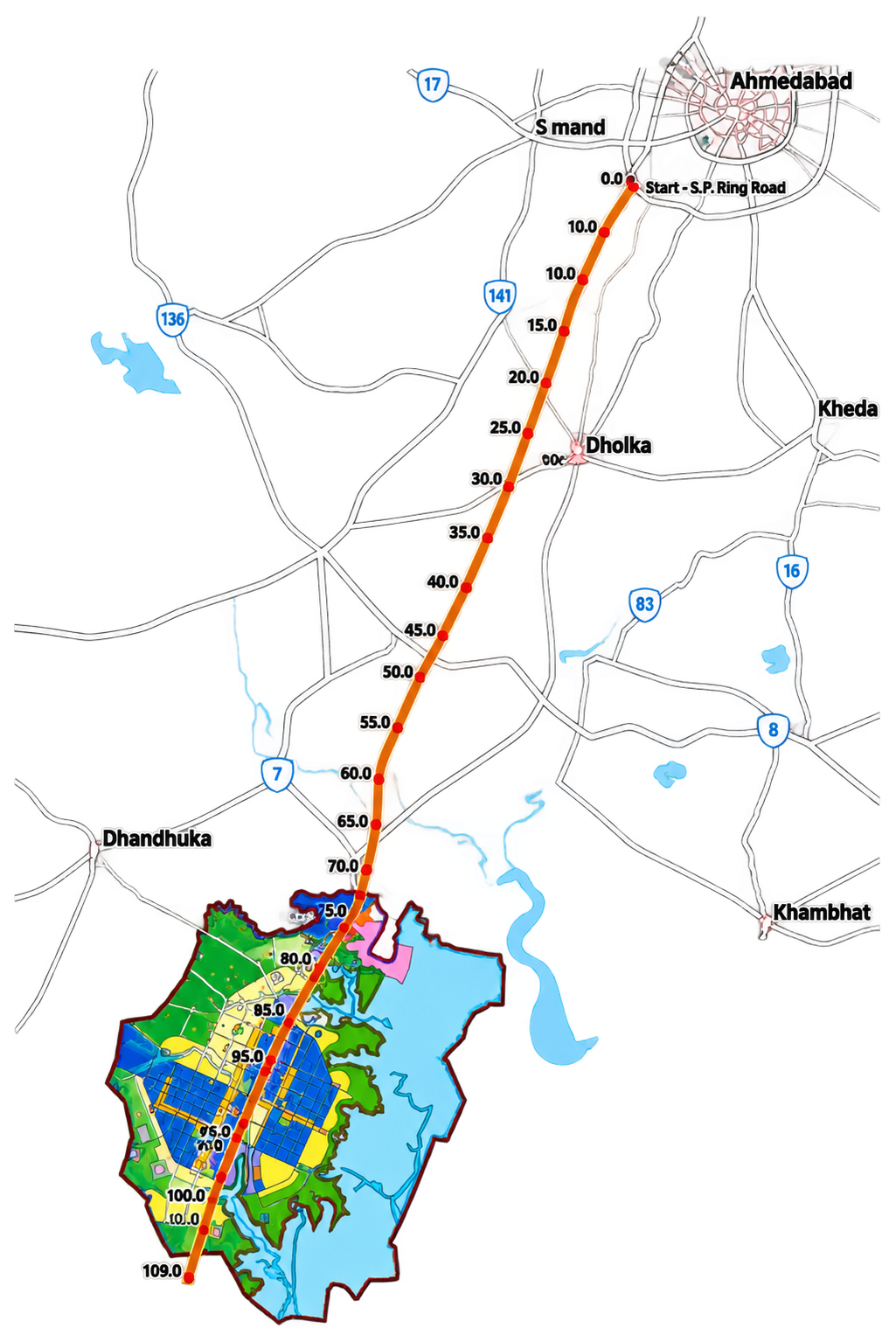
The expressway is the spine of the whole connectivity plan. The Ahmedabad–Dholera Greenfield Expressway runs 109.019 km from Sarkhej on Ahmedabad's outer ring (where it meets the Sardar Patel Ring Road) to Adhelai near Bhavnagar at its southern end. It is access-controlled, built as a four-lane dual carriageway with room to widen to eight, and it carries the designations NH-751 and NE-8.
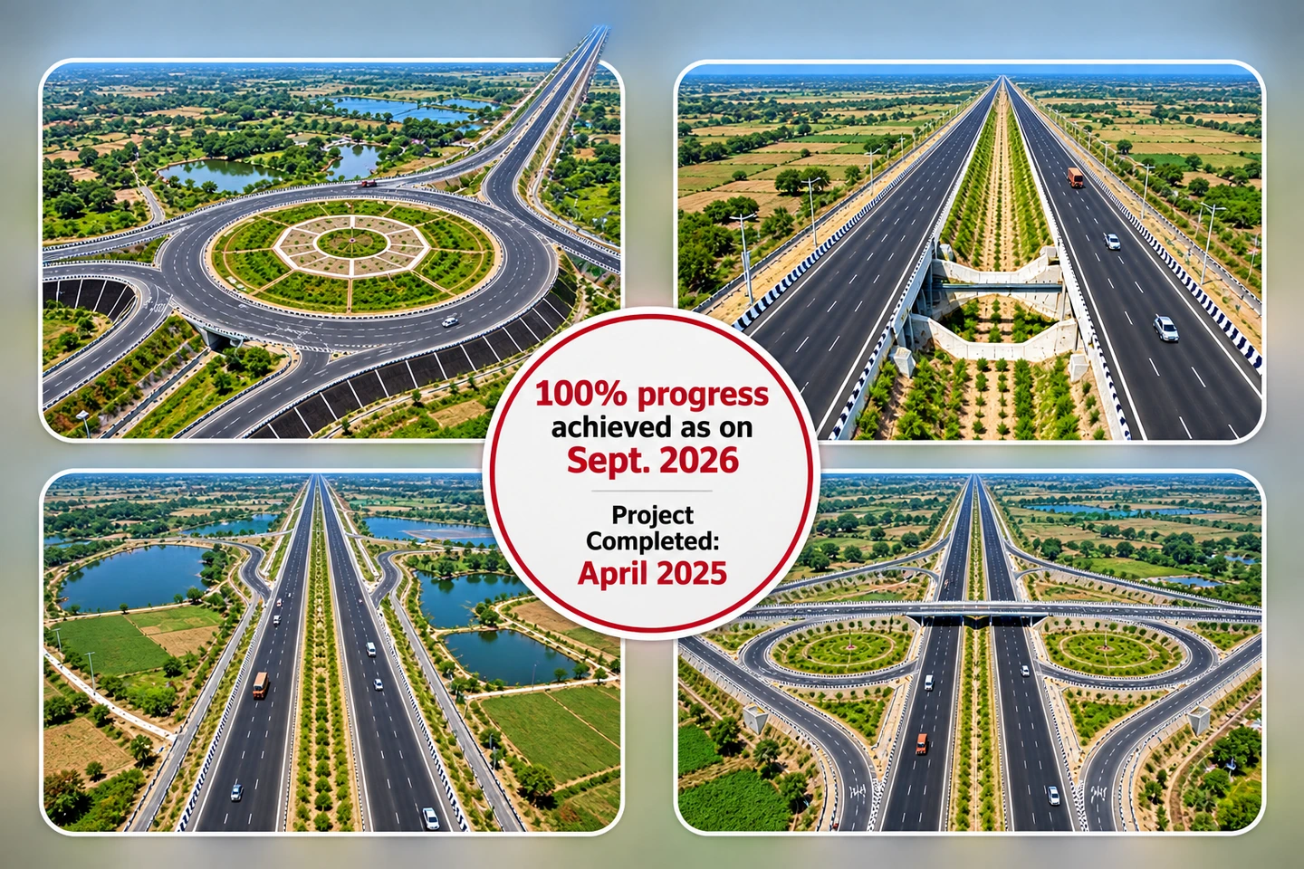
Its logic is straightforward. Before this corridor, traffic between Ahmedabad and the Dholera coast crawled through town centres on older state highways, a journey that could take two and a half to three hours. The expressway replaces that with a single high-speed alignment. Passenger design speed is 120 km/h and cargo 80 km/h, with a design capacity around 25,000 passenger car units a day in both directions.
The history is worth knowing because it explains the alignment. The project was proposed in 2010 by the Gujarat state road department as part of the early DMIC thinking, and the National Highways Authority of India took it over around 2019, commissioning a detailed project report and dividing construction into four packages between Sarkhej and Adhelai. It was inaugurated and dedicated to the nation on 31 March 2026, a record kept in the PMO's official event listing. A 9.56 km spur branches off near the end of the route to connect directly with Dholera International Airport, so air cargo and road freight share one corridor rather than two.
The alignment also does quieter work. It threads through predominantly rural land between Ahmedabad's ring and the SIR boundary, which is why land acquisition covered 24 villages and why the route passes interchanges at Sindhrej, Vejalka, the airport junction and inside the SIR itself. Each interchange is a decision about which local roads feed the high-speed spine and which stay out of it. I find the alignment satisfying because it is unsentimental: it does not pretend to serve every village equally, it just picks where the on-ramps go and lets the other roads keep their old jobs. The ground reality page also carries a first-person note on what the drive actually feels like: see Chapter 5's published travel note.
12.2 The road network beyond the expressway
An expressway is only as useful as the roads that feed it. The wider road network has three layers.
The first layer is the state highway system that existed before the SIR, including routes toward Bhavnagar and the coastal talukas. These roads carry most of the region's existing traffic and were part of why the expressway's southern terminus was placed at Adhelai, where it can hand traffic toward Bhavnagar rather than dead-ending at the coast.
The second layer is the internal SIR grid. The development plan lays out a hierarchical grid of arterial and sub-arterial roads inside the Activation Area and the townships, built TP scheme by TP scheme. These are the roads industrial plots actually front onto. Their width standards, junction design and underground utility corridors follow the development regulations rather than highway norms, because their job is local access, not speed.
The third layer is the set of link roads and service roads that connect the grid to the expressway's interchanges. A factory in the Activation Area reaches the expressway through a short local drive, an interchange, and then a nonstop run to Ahmedabad. That handoff between slow local access and fast regional movement is the whole design idea.
12.3 Dholera International Airport
This airport has a dedicated deep dive — site, design, ownership, construction timeline and current status — at Dholera International Airport.
Dholera International Airport is a greenfield airport at Navagam village, roughly 20 km from the SIR core and about 80 km southwest of Ahmedabad. The site covers around 1,426 hectares, acquired for the purpose, and the airport is designed as a Code 4E facility, which in plain terms means a runway and airfield capable of handling wide-body aircraft.
Ownership is a three-way public structure through Dholera International Airport Company Limited: the Airports Authority of India holds the majority stake, the Government of Gujarat holds the second-largest share, and NICDIT, the national industrial corridor institution, holds the remainder. That structure matters because it makes the airport a public commitment rather than a private bet.
The design divides construction into parts. Part A is the airfield civil works: the runway, parallel taxiways, rapid-exit taxiways, aprons, perimeter roads and airside drainage. Part B is the vertical infrastructure: a passenger terminal planned at roughly 20,000 sq m over three levels, a nine-storey air traffic control tower, a cargo complex with temperature-controlled storage and customs facilities, a technical block and an electrical substation. The airfield part was completed in December 2025, and at a 14 July 2026 official review the overall project stood at roughly 80 percent with the terminal around three-quarters done.
One dated event already belongs to this airport's record: on 4 June 2026, the Airports Authority of India carried out the first successful test flight at Dholera International Airport — a calibration aircraft, registration VT-CNS, touched down on the newly constructed runway at Navagam, the first aircraft landing since construction began. Calibration flights are not ceremonial: the aircraft flies repeated approaches to calibrate navigation aids, check approach procedures and confirm that the runway surfaces, lighting and signalling systems behave as designed, which is the validation step an airport needs before it can move toward certification for commercial operations (intelligence entry).
The airport is meant to do three jobs. For passengers, it gives the SIR and the region direct air access instead of routing everything through Ahmedabad airport. For industry, the cargo complex is the point: semiconductor-grade equipment, aerospace components and temperature-sensitive pharmaceuticals move better by air, and the airport's proximity to the industrial zone is the reason the expressway has a dedicated airport spur. For the corridor as a whole, an airport inside a DMIC node is part of the standard playbook that made cities like Shenzhen and Incheon work, where air freight and sea freight complement rather than compete.
12.4 Rail connectivity today
What exists now is conventional. The region around Dholera is served by ordinary broad-gauge lines of the Western Railway network, with the nearest substantial junctions toward Ahmedabad and Bhavnagar. These lines move goods wagons and ordinary passenger trains at conventional speeds, and they predate the SIR by decades.
This matters as a baseline. The SIR's land already had rails, just rails built for agricultural freight and small-town traffic. The question the connectivity plan answers is whether the region has a rail system suited to moving an industrial workforce daily and heavy freight reliably. The conventional network cannot do the first at the volume a 920 sq km industrial city implies, which is what the next section addresses.
12.5 The Ahmedabad–Dholera rail corridor
The headline rail project is the Ahmedabad (Sarkhej)–Dholera semi-high-speed double line, approximately 134 km long. The Union Cabinet approved it on 13 May 2026 with an estimated cost of about ₹20,667 crore, and in August 2026 Western Railway floated the engineering, procurement and construction tender at ₹18,901.68 crore. A tender is a procurement step, not a contract award, so the project is approved and in procurement, with a completion horizon that official records place in the 2030–31 window.
The design is unusual for India. It is planned as a double-line broad-gauge corridor with a large share of the route elevated on viaducts, a direct response to the low-lying Gulf of Khambhat landscape where flooding and poor ground are persistent facts. The corridor runs broadly parallel to the expressway, which lets the two systems share a corridor of land and utilities instead of consuming two.
The logic of the alignment is to stitch Dholera into Ahmedabad's transit future. The northern anchor is planned at Sarkhej, feeding into Ahmedabad's urban rail fabric, and the project's framing in official releases connects it to the wider regional system including the Mumbai–Ahmedabad high-speed rail corridor's Ahmedabad presence. Intermediate stations serve the towns along the expressway's own path, so rail and road complement each other rather than duplicating stops.
The purpose stated in the approval is mass movement of people, at semi-high speed, between the Ahmedabad metropolitan labour market and the Dholera industrial zone. A city that expects factories, chip fabs and an airport cannot assume workers will drive 100 km each way forever. The rail corridor is the long-term answer to that problem. When construction physically begins and how the stages sequence is a Chapter 6 question.
12.6 Dedicated freight and logistics connectivity
Moving people is half the problem; moving cargo is the other half. The Dedicated Freight Corridor, the Eastern and Western freight corridors built under the DMIC programme, carries container and bulk freight at freight-specific speeds on dedicated tracks separate from passenger rail. The Western Dedicated Freight Corridor's Rewari–Mumbai segment is the relevant national asset: its terminus region around Ahmedabad and its corridor down toward Mumbai is what connects Dholera's cargo to the national freight network.
The Dedicated Freight Corridor is also a completed system, not a plan. In June 2024 India completed the full DFC network, with the Prime Minister inaugurating the final ~326 km, ₹20,700 crore segment (intelligence entry). The network is in heavy daily use: on 13 September 2026 DFCCIL recorded 927 train interchanges in a single day, 423 of them on the Western DFC.
Dholera's freight story is therefore an indirect one by design. Freight leaves the SIR by road on the expressway, or by rail once the new corridor is built, and joins the dedicated freight system through the interchange points along that corridor. The Bhimnath logistics hub planned as part of the rail project's station pattern is one such interchange, a place where goods transfer between local road haulage and line-haul rail.
Within the SIR itself, logistics land is planned into the industrial fabric: warehousing zones, container depots and truck-oriented plots sit near the expressway interchanges so that the first and last kilometres of any shipment stay short. The design assumption throughout is multimodal: no single mode carries everything, and the value comes from cheap transfers between them.
12.7 Port connectivity
Here is the part most casual summaries get wrong: there is no port at Dholera. The original plan for a greenfield deepwater port in the Gulf of Khambhat, a joint venture concept backed in the mid-2000s, was abandoned after hydrographic studies showed why the gulf resists ports. The funnel-shaped estuary has a tidal range of roughly ten metres, strong tidal currents, and enormous sediment discharge from rivers including the Sabarmati, Mahi and Narmada. Shoals migrate; measured siltation has been dramatic enough that any port there would need continuous, financially punishing dredging.
So the strategy flipped. Instead of bringing ships to Dholera, the plan connects Dholera to ships. The expressway and, in time, the rail corridor link the SIR to Gujarat's existing ports on the Saurashtra and Kutch coasts, including Pipavav, Kandla and Mundra, and to the ports near Bhavnagar across the gulf. The maritime function of Dholera is a routing problem, solved with inland links rather than dredging.
None of this is a compromise to be apologised for. Existing ports already have channels, cranes, customs and shipping lines calling. A new industrial city that plugs into that network on day one, via a 109 km expressway and a planned rail line, gets seaborne trade without betting its budget on beating the Gulf of Khambhat's hydrology.
12.8 Maritime logistics around the gulf
On the far side of the gulf, Bhavnagar is the port story to watch. Gujarat Maritime Board's modernisation programme there includes a planned multi-terminal port with container, liquid cargo, vehicle carrier and multipurpose berths, and a tidal lock gate system engineered to hold a stable, low-sediment basin behind a gate, a design used at some of the world's largest tidal ports because it cuts maintenance dredging. The programme also includes what its promoters describe as a first-of-its-kind compressed natural gas import terminal.
For Dholera, Bhavnagar's significance is proximity. Across the gulf it sits close to the expressway's southern terminus at Adhelai, which is part of why that terminus was chosen. A working cargo port near the southern end of the corridor gives the SIR a maritime gateway that does not require the full loop around the gulf toward Saurashtra.
The vocabulary needs care here: these are Gujarat Maritime Board and state programmes on the coast, not Dholera projects. Their planning horizons run toward the state's long-term port vision documents. What Dholera contributes is demand and inland access.
12.9 Multimodal logistics
Every system above meets in one discipline: interchange. A semiconductor-ready supply chain might move a photolithography machine from a ship at a proxy port onto a truck, down the expressway, into the SIR, while its inputs arrive by air at the new airport and its people arrive by the future rail line. Each transfer point is a designed piece of infrastructure, not an accident.
The multimodal layer in and around Dholera includes the airport's cargo complex, the warehousing and truck-terminal zones inside the industrial fabric, the planned rail-side logistics facilities at stations such as Bhimnath, and the road-rail interchanges where the corridor's stations meet the expressway's interchanges. The design intent, borrowed from every successful industrial corridor, is to keep the expensive line-haul legs long and the cheap local legs short.
Because this layer depends on the others, it inherits their sequencing. Road-based logistics can function now; airport cargo waits on the airport; rail-side logistics wait on the rail corridor. That staging is why the multimodal story should always be read asset by asset, with status from Chapter 6.
12.10 Regional and national connectivity
Seen from further out, the layers form one picture. Regionally, the expressway binds Dholera to Ahmedabad's economy, labour pool and airport within a single corridor, while the road network south toward Bhavnagar ties the SIR to the coastal side of the gulf. Nationally, the SIR sits on the Delhi–Mumbai Industrial Corridor's freight spine, with the Western Dedicated Freight Corridor as its cargo artery and the expressway's junctions feeding national highway routes toward Saurashtra and the rest of Gujarat.
Internationally, the connections are indirect but real: air cargo through a greenfield airport designed for wide-body freighters, and sea freight through Gujarat's established port network. The energy systems that make industrial output possible in the first place, including the planned renewable capacity around the region, are covered in Chapter 14 — energy, and water systems in Chapter 13.
Stated plainly, Dholera's connectivity is a layered bet. The road layer is built. The airport is close to structural completion. The rail corridor is approved and in procurement with a horizon in the 2030s. The maritime layer is a routing strategy, not a local port. Each layer was designed to close a specific gap, and the plan only works when the layers operate together, which is why status and design are kept apart on this site.